
Old Bridge Neighbor Records by Block
There is no official list of every household around an Old Bridge address. A reliable check of Old Bridge neighbors separates parcel facts, recorded ownership, civic geography, and public organization information. The county parcel layer is the starting point because it ties a property location to municipality, block, lot, PAMS PIN, land description, and selected sale or deed pointers. From there, the land index can confirm a recorded transaction. These sources describe property records, not an assertion about who is currently at a home.
| Source | What It Shows About a Block | Access |
|---|---|---|
| Middlesex parcel layer | Parcel geography, property location, municipal field, block/lot, and public deed or sale pointers | Public GIS data; protected owner fields may be absent |
| County land-record index | Recorded parties, instrument, document type, and recording date | Online index, record room, or copy request |
| Ward map | Official election geography and parcel context | County map and related election materials |
| Community organization page | Public board, contact channel, notices, and named community context | Organization’s public page only |
| Newspaper or directory source | Dated historical presence near a street or neighborhood | Library, archive, or historical collection |
Start with the smallest useful area, usually the subject parcel and immediately adjoining parcels. A land-record party can be a former owner, trustee, estate, or entity. A postal place can differ from the township’s jurisdiction. For a current block question, preserve each source’s date and never treat an owner name, ward, or old directory entry as proof of present occupancy.
Set an Old Bridge Block Boundary
Old Bridge address research uses four separate fields: municipal jurisdiction, postal city, ZIP, and parcel location. A mailing label such as Matawan or South Amboy does not by itself place a property outside Old Bridge Township. Normalize the street address with USPS ZIP Lookup, then compare the county data for property location, municipality, block, lot, and ZIP. Keep a unit number only if it is public and needed. Do not infer one from a similar address.
The geographic distinction matters along postal overlays. County and institutional sources document Old Bridge addresses using 08857, 08859, 08879, 07735, and 07747. The county parcel municipal field, rather than the postal city alone, is the better test for an Old Bridge block and its nearby neighbors. This is especially useful around Laurence Harbor, Parlin and Ernston, and western Route 516 addresses.
Note: A ZIP code routes mail, while the municipal parcel field establishes the township geography for a record check.
Map an Old Bridge Neighbor Block
Use a short parcel trail for a neighbor lookup. The goal is to identify public parcel relationships around the address, not to build a list of people. The county layer can show PAMS PIN, municipality, block, lot, qualifier, property location, property class, land description, acreage, year built, old block and lot values, sale information, and deed book or page pointers where available. Owner-name and owner-address fields can be suppressed, so missing data is a limit, not a problem to work around.
- Validate the address and locate its parcel in the Middlesex County public parcel service.
- Record the subject parcel’s municipality, PAMS PIN, block, lot, property location, and public deed reference.
- Inspect only the adjoining parcels needed to understand the immediate block, keeping the same fields and source date for each.
- Use a public deed pointer in the Middlesex land-record search to identify a recorded transaction, then label the party and date exactly as recorded.
This flow is address to parcel identity to recorded instrument to dated interpretation. It is deliberately narrower than a streetwide search for Old Bridge neighbors. For the complete by-street records chain, use the Old Bridge Street Directory after the immediate block is understood.
Read Old Bridge Parcel Fields
The Middlesex parcel FeatureServer exposes the layer’s field list and query controls. Useful block-level fields include property location, municipality, PAMS PIN, block, lot, qualifier, property class, land description, ZIP, old block or lot values, additional lots, sale date, sale price, deed book and page, acreage, year built, and last update. A sale date, year built, or land description describes a parcel record. It does not identify a resident.
The source view below is the county parcel-layer metadata and field interface.
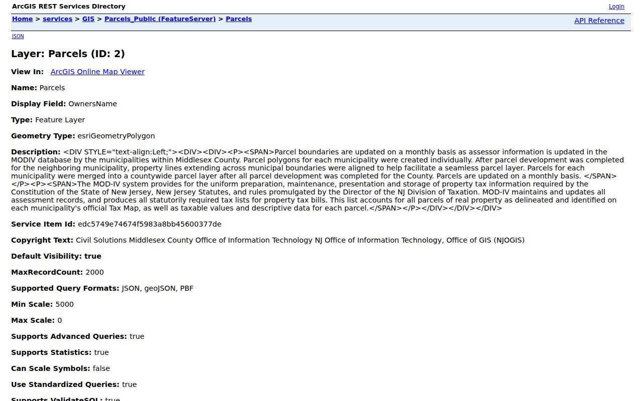
NJGIN guidance says parcel services can be searched by address, county, municipality, block, and lot, but also warns that parcel edges may not align perfectly across county boundaries. It further notes that owner names are redacted from hosted parcel and tax database services under Daniel’s Law protections. Treat the map as a public geography and parcel-reference source, then ask the custodian for a defined record when a needed public field is not shown.
- Parcel
- A mapped unit of land used in property records. It can be identified by block, lot, qualifier, PAMS PIN, or other local identifiers.
- Situs or property location
- The physical property address shown by the record. It can differ from a mailing address.
- Deed book and page
- A pointer to a recorded document in the County Clerk’s land-record system, not proof of current occupancy.
Use Old Bridge Ward Geography
Old Bridge has six wards according to the county’s January 14, 2022 ward map, which shows 2021 parcel context. A ward is an election geography, not a neighborhood identity or a list of neighbors. Add a ward or district only when an official map, voter form, or election record supports it. The statewide voter status tool is intended for exact-name self-checking, and an active or inactive registration status does not prove that someone presently lives at a specific address.
The Middlesex County Board of Elections is the appropriate contact for a defined election record or voter-form question. New Jersey election records can include public fields subject to statutory redactions. Do not use a ward map, sample ballot, or registration self-check to assemble a block roster.
Use Old Bridge Community Notices
Public community pages add a useful layer for Old Bridge neighbors when they are treated as organization records. The township Municipal Alliance identifies civic associations, religious groups, PTAs, school board, chamber, public-safety, and municipal participants as community institutions. A public page can establish a community name, notice date, public contact, or board information. It cannot establish membership, household composition, or a person’s home address.
| Public Community Source | Block-Level Value | Appropriate Use |
|---|---|---|
| Deep Run HOA | Named community, public board and contact channel, notices | Community context, not a member list |
| Lakeridge West notices | Township notices carried for a named community | Date and local notice context |
| Old Bridge Municipal Alliance | Public civic-network categories | Organization-level context only |
The Deep Run public page provides a concrete example of a community-specific source with board and public contact information.
Deep Run’s page includes a Route 9 Old Bridge mailing context, public contact channel, and a 2026 annual-meeting notice. Those details document the organization’s own public communications. They should not be used to infer who belongs to the association or who lives on a nearby parcel.
Compare Old Bridge Neighbor Sources
Official and commercial categories serve different purposes. Official sources have named custodians, defined access rules, and a record date, but each source is limited to its own subject. Commercial neighbor tools may combine publicly available and other data, yet their currency, method, and interpretation should be checked independently. Neither category can convert a parcel owner, organization contact, or historical mention into a current resident without support.
| Category | Strength | Limit for Neighbor Questions |
|---|---|---|
| Official parcel and land records | Identifies a defined parcel and recorded document trail | Ownership or transaction is not present occupancy; protected fields may be removed |
| Official community and election pages | Shows a public notice, civic geography, or organization fact | Does not provide a household roster or a current address claim |
| Commercial neighbor tools | May offer a convenient starting point for a public name or address | May be incomplete, dated, or mismatched; verify with the custodian |
For a personal safety or property-curiosity question, retain only the smallest fact needed and the official source that supports it. A dated county record is usually more informative than a broad, unverified compilation.
Trace an Old Bridge Block Backward
Older block research needs historical names as well as today’s map. Old Bridge was Madison Township until the 1975 referendum/name transition in the official history, while the Thomas Warne Museum gives 1976. Search Madison Township, Madison, Old Bridge, and South Amboy Township in deeds, newspapers, directories, maps, and museum materials. Preserve the source’s own municipal label rather than changing an old record to a modern one.
County historical aerial photography provides physical snapshots for 1962, 1967, 1974, 1980, 1987, and 1998. It can show that a road, structure, clearing, or parcel configuration existed at a date, but it cannot identify an occupant. Pair aerials with a dated deed, directory, planning file, or Thomas Warne Museum research lead when examining a changed block.
Request Old Bridge Block Records
When the map or index does not show a needed public document, make a focused request to the proper custodian. Under the New Jersey Open Public Records Act, N.J.S.A. 47:1A-1 et seq., requests should identify specific existing records, a reasonable date range, and the department or subject address. The state OPRA guidance explains that agencies are not required to create a new list or answer a broad research question.
For an Old Bridge planning, permit, or board record, give the address, block and lot if known, application type, board, year range, and desired item such as a resolution, plan set, minute, notice, or correspondence. The Planning Department identifies those public-viewing categories. Expect redactions where a file includes protected personal information.
Neighbor Lookup Privacy Limits
New Jersey law protects important boundaries. OPRA redactions can shield identifiers, signatures, unlisted telephone numbers, victim details, and protected addresses. Daniel’s Law protections can remove names from parcel and tax services, and the Address Confidentiality Program uses a substitute address for eligible participants. A missing owner field or substitute address is a stop signal, not an invitation to search around the protection.
Use public record information only for a personal and lawful purpose. Keep source dates and correction paths with any note, and contact the custodian when a record appears wrong or incomplete.
Lawful use. Old Bridge neighbor information is for personal, lawful research and community awareness. Never use public records to stalk, harass, intimidate, or harm another person.